Hurricane Marie swells batter Southern California coast, 24 homes evacuated
Synopsis
The remnants of Hurricane Marie sent powerful long-period swells into Southern California last week, evacuating 24 homes in Long Beach, opening a sinkhole at a property reportedly linked to Nicolas Cage in Malibu, and shutting part of America's second-busiest intercity rail corridor in San Clemente — all before a potentially more destructive El Niño winter has even begun.
Key Takeaways
Surf from former Hurricane Marie battered the Southern California coast last week, causing widespread beach erosion and structural damage.
At least 24 oceanfront homes were evacuated on the Alamitos Peninsula in Long Beach due to seawall overtopping and possible foundation damage.
A sinkhole opened at a Malibu property reportedly owned by actor Nicolas Cage , triggering a gas leak and a local emergency declaration along Sea Level Drive .
Waves overtopped the Los Angeles-San Diego-San Luis Obispo Rail Corridor in San Clemente , forcing partial closure of the 351-mile , second-busiest intercity rail route in the US.
Climate scientist Daniel Swain warned the event is 'just a preview,' with El Niño conditions expected to intensify coastal flooding and erosion risks this winter.
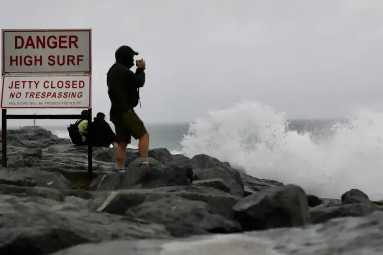
Powerful surf driven by the remnants of former Hurricane Marie hammered Southern California's coastline last week, stripping sand from beaches, damaging homes and walkways, and laying bare the deepening vulnerability of oceanfront communities from Malibu to San Diego County. The episode has reignited concern among coastal scientists and officials about the region's long-term resilience to storm-driven erosion.
Worst Damage: Alamitos Peninsula
The most severe destruction was recorded along the Alamitos Peninsula in Long Beach, where days of large breaking waves overwhelmed sand berms and pounded a seawall protecting homes packed tightly between the Pacific Ocean and narrow streets. At least 24 oceanfront homes were placed under evacuation orders while authorities assessed structural damage and the possibility of foundation undermining.
The immediate trigger was the long-period swells generated by Hurricane Marie, which remained far offshore but directed substantial wave energy toward south- and southwest-facing beaches. The combination of high surf and high astronomical tides amplified coastal flooding and erosion risks considerably.
Nicolas Cage Property and Local Emergency
In Malibu, the storm attracted national attention when a sinkhole opened in the driveway of an oceanfront home reportedly owned by Oscar-winning actor Nicolas Cage, known for films including 'Leaving Las Vegas', 'National Treasure' and 'Face/Off'. The collapse triggered a gas leak, prompting emergency crews to shut off utilities. Malibu officials subsequently declared a local emergency for affected properties along Sea Level Drive.
Rail Corridor Disrupted in San Clemente
In San Clemente, high tides and powerful waves overtopped the coastal rail line, causing further erosion and slope damage and forcing the closure of an affected section of the track. The corridor — formally the Los Angeles-San Diego-San Luis Obispo Rail Corridor — is the second-busiest intercity passenger rail corridor in the United States. Parts of the 351-mile route run directly along coastal bluffs and beaches in Southern California, where waves, landslides and slope failures have repeatedly forced emergency repairs and service disruptions.
El Niño Warning and the Climate Context
Coastal scientists say erosion is a natural process, but risks escalate sharply when beaches have limited room to migrate because of development and shoreline structures. In heavily developed stretches of Southern California, seawalls, homes, roads and rail lines constrain the natural movement of sand as sea levels continue to rise.
Climate scientist Daniel Swain warned during a public discussion last week that conditions could worsen. 'Unfortunately, this is just a preview,' Swain said, cautioning that coastal flooding risks could intensify in the autumn and winter if El Niño conditions strengthen — a prospect that forecasters say is increasingly likely. A strengthening El Niño is expected to bring wetter and stormier weather to Southern California later this year.
Former Malibu resident S.A. Baker captured the broader anxiety among locals. 'With global warming, superstorms and ocean current shifts, I'm afraid it's only going to get worse,' Baker said. 'Las Vegas might be beachfront property one day if this keeps up.'
What Comes Next
Local officials remain focused on repairs and public safety, with authorities warning of dangerous surf and rip currents. Rainfall may also increase runoff and temporarily worsen water quality near beaches. The latest storm has underscored how even a tropical system tracking hundreds of miles offshore can inflict significant damage along Southern California's exposed coastline — and with El Niño looming, coastal communities may face a difficult winter ahead.
Point of View
Roads and critical rail infrastructure directly on eroding bluffs and beaches has long been flagged by coastal engineers, yet development pressures have consistently overridden managed-retreat planning. The Nicolas Cage sinkhole is a vivid symbol, but the more consequential story is the second-busiest US intercity rail corridor going down because waves hit a bluff. With El Niño loading the dice for a wetter, stormier winter, the question for policymakers is no longer whether to act but whether they can act fast enough.
NationPress
14 Sept 2026
Frequently Asked Questions
What caused the coastal erosion in Southern California last week?
The erosion was caused by powerful long-period swells generated by the remnants of former Hurricane Marie, which stayed far offshore but sent significant wave energy toward south- and southwest-facing beaches. The swells combined with high astronomical tides to amplify coastal flooding and erosion along communities from Malibu through Orange County and into San Diego County.
Which areas were worst affected by the storm damage?
The Alamitos Peninsula in Long Beach suffered the worst damage, with at least 24 homes evacuated after waves overwhelmed sand berms and a protective seawall. Malibu, San Clemente, and areas through Orange County and San Diego County also recorded flooding, erosion and infrastructure damage.
What happened at Nicolas Cage's Malibu property?
A sinkhole reportedly opened in the driveway of an oceanfront Malibu home owned by Oscar-winning actor Nicolas Cage, causing a gas leak that prompted emergency crews to shut off utilities. Malibu officials declared a local emergency for affected properties along Sea Level Drive.
Why was the San Clemente rail line shut down?
High tides and powerful waves overtopped the coastal rail line in San Clemente, causing erosion and slope damage that forced closure of an affected section of the Los Angeles-San Diego-San Luis Obispo Rail Corridor. The 351-mile corridor is the second-busiest intercity passenger rail route in the United States and is particularly vulnerable where it runs along coastal bluffs and beaches.
Could conditions worsen for Southern California this winter?
Yes, according to climate scientist Daniel Swain, who called the recent damage 'just a preview.' A strengthening El Niño is expected to bring wetter and stormier conditions to Southern California later in 2026 and through winter, potentially increasing coastal flooding and erosion risks significantly.