Khagaria-Purnea four-lane highway: ₹3,936 crore boost for Bihar's banana and makhana belt
Synopsis
A ₹3,936 crore CCEA-approved highway project could reshape Bihar's agricultural economy — not by adding lanes alone, but by slashing transit time for bananas and makhana from over 3.5 hours to under 2, while building flood resilience into a corridor that has historically buckled every monsoon season.
Key Takeaways
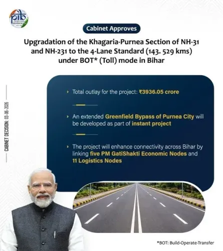
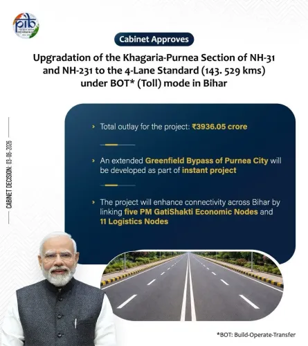
The CCEA has approved four-laning of the Khagaria–Purnea section of NH-31 and NH-231 at a cost of ₹3,936.05 crore .
Travel time on the corridor is expected to fall from 3.5–4 hours to 1.5–2 hours after upgradation.
The project directly benefits Bihar's banana and makhana farmers by reducing spoilage and improving market access.
Flood-resilient engineering — improved drainage, stronger pavement, better road geometry — is built into the design to counter disruptions from the Kosi and Ganga systems.
The corridor will connect 5 PM Gati Shakti Economic Nodes and 11 logistics nodes , including four railway stations and one airport.
The highway strengthens interstate links between Bihar , West Bengal , and Jharkhand .
The Cabinet Committee on Economic Affairs (CCEA) has approved the upgradation of the Khagaria–Purnea section of NH-31 and NH-231 to a four-lane highway at a cost of ₹3,936.05 crore, a move that is expected to transform agricultural logistics across Bihar's Seemanchal region, according to a government factsheet released on Sunday, 19 July. The project, cleared by the Ministry of Road Transport and Highways, directly targets the supply-chain bottlenecks that have long undermined the commercial potential of Bihar's banana and makhana economies.
Why This Highway Matters for Bihar's Farmers
Before sunrise each day, trucks carrying freshly harvested bananas depart from farms around Khagaria, while sacks of makhana move out of processing centres in Purnea — one of India's largest makhana-producing hubs. For perishable produce like bananas, where quality deteriorates by the hour, every delay on a congested two-lane road translates directly into financial loss for growers.
The four-laning is expected to cut travel time on the corridor from the current 3.5 to 4 hours down to approximately 1.5 to 2 hours, according to the government factsheet. Faster, more reliable transit is projected to reduce spoilage, preserve produce quality, and improve price realisations at distant markets — outcomes that could meaningfully raise farm incomes across Khagaria, Bhagalpur, Katihar, and Purnea districts.
Flood Resilience Built Into the Design
Eastern Bihar's road network has historically suffered severe disruption from seasonal flooding driven by the Kosi and Ganga river systems. The upgraded corridor is designed to address this vulnerability through improved road geometry, strengthened pavement structures, and modern drainage integration — engineering interventions intended to keep the highway operational year-round, even during the monsoon months when agricultural output peaks and logistics pressure is highest.
Strategic and Multimodal Connectivity
The project's significance extends beyond intra-state agriculture. The upgraded highway will reinforce road links between Bihar and West Bengal, while also improving access to Jharkhand via the broader National Highway network — making it a critical artery for eastern India's interstate commerce.
The corridor will also connect five PM Gati Shakti Economic Nodes — including one textile cluster, two mega food parks, and two fishing and seafood parks — along with 11 logistics nodes comprising four major railway stations, one airport, four National Highways, and two State Highways. This multimodal integration is expected to significantly deepen the region's economic connectivity and reduce last-mile logistics costs for exporters and traders.
Addressing Long-Standing Bottlenecks in Seemanchal
The existing two-lane corridor has long been plagued by sharp curves, inadequate road geometry, and severe congestion through densely populated urban and semi-urban stretches across the four districts it serves. The Seemanchal region — which includes districts such as Katihar and Khagaria — has historically recorded longer travel times to administrative, educational, and economic hubs compared to much of the rest of Bihar.
Officials say the four-laning will address these structural deficiencies while linking the region more directly to Patna and major commercial centres across the east. With the CCEA approval now in place, the project moves into the implementation phase — and for Bihar's farmers, the clock on that improvement has started ticking.
Point of View
But the deeper story is about structural neglect in Seemanchal — a region that has sat at the edge of Bihar's development map for decades. Cutting travel time by half matters, but only if the flood-resilience engineering holds; eastern Bihar's roads have been upgraded before and still buckled under Kosi floods. The real test will be whether the drainage and pavement improvements survive the first heavy monsoon post-completion. The Gati Shakti node linkages are promising on paper, but food parks and logistics hubs in this region have historically underperformed due to power and cold-chain gaps that a highway alone cannot fix.
NationPress
18 Oct 2026
Frequently Asked Questions
What is the Khagaria–Purnea four-lane highway project?
It is a ₹3,936.05 crore project approved by the Cabinet Committee on Economic Affairs (CCEA) to upgrade the Khagaria–Purnea section of NH-31 and NH-231 in Bihar from a two-lane to a four-lane highway. The project aims to improve agricultural logistics, reduce travel time, and strengthen interstate connectivity across eastern India.
How will the highway benefit Bihar's banana and makhana farmers?
The upgraded corridor is expected to cut transit time from 3.5–4 hours to 1.5–2 hours, reducing spoilage of perishable produce like bananas and improving price realisations for farmers. Purnea is one of India's largest makhana hubs, and faster connectivity is expected to open better market access for both crops.
How does the project address Bihar's recurring flood problem?
The design incorporates flood-resilience measures including improved road geometry, strengthened pavement structures, and modern drainage systems, aimed at keeping the corridor operational during monsoon months when the Kosi and Ganga river systems typically disrupt road connectivity in eastern Bihar.
Which districts does the Khagaria–Purnea corridor pass through?
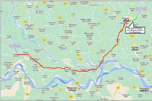
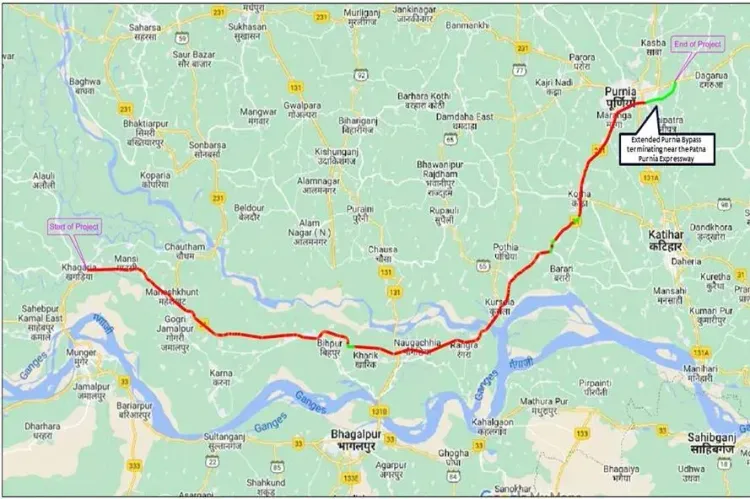
The corridor runs through Khagaria, Bhagalpur, Katihar, and Purnea districts, linking the Seemanchal region to Patna and providing improved access to West Bengal and Jharkhand via the National Highway network.
What economic nodes will the upgraded highway connect?
The corridor will connect five PM Gati Shakti Economic Nodes — including one textile cluster, two mega food parks, and two fishing and seafood parks — along with 11 logistics nodes comprising four major railway stations, one airport, four National Highways, and two State Highways.