

Super El Niño batters California coast with record rains, king tides threat ahead
Synopsis
California is facing what scientists call a 'triple threat' — record rainfall, rising sea levels, and king tides — all driven by what NOAA says has a 60% chance of being the most intense El Niño since records began in 1950. With peak tidal cycles still weeks away and $312 million already spent on coastal highways, the worst may genuinely be yet to come.
Key Takeaways
San Francisco recorded 2.64 inches of rain in one day on Wednesday, breaking a century-old record for that date.
More than 51,000 electricity customers lost power across the Bay Area by Wednesday afternoon. 'King tides' running Sunday through 27 November could push coastal water levels above 8 feet in Southern California.
NOAA estimates a 60% probability of a 'historic' El Niño — the strongest since records began in 1950 .
Governor Gavin Newsom declared a statewide emergency on 21 September and established a Highway 1 Task Force on 27 October .
Emergency spending along Big Sur's Highway 1 reached roughly $312 million from 2020 to 2026 .
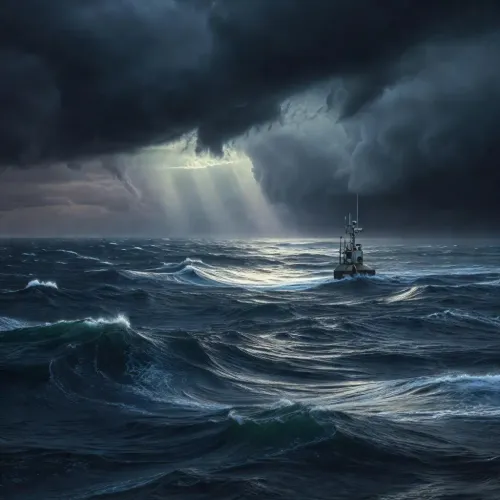
Record rainfall, destructive swells, and crumbling seawalls are hammering California's coastline this week, as a Super El Niño-driven atmospheric river pushes the state toward what scientists warn could be an unprecedented season of coastal damage. The US National Weather Service issued fresh alerts on Thursday, 22 November, cautioning residents along the California coast about rapidly intensifying storms.
Record-Breaking Rainfall Hits the Bay Area
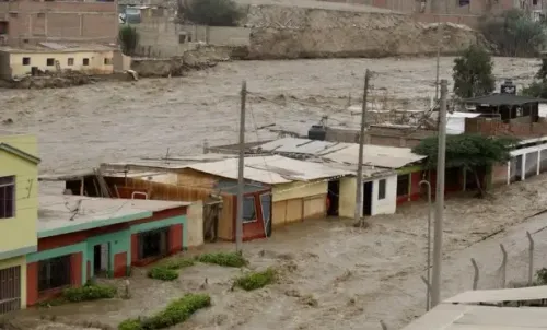
San Francisco recorded 2.64 inches of rainfall in a single day on Wednesday, breaking a date record that had stood for over a century, according to reports. The deluge — driven by an atmospheric river supercharged by El Niño conditions — flooded buildings, stranded vehicles on Bay Area freeways, and knocked out power for more than 51,000 electricity customers by Wednesday afternoon.
The National Weather Service flagged rainfall rates exceeding one inch (approximately 25.4 mm) per hour, prompting the issuance of multiple flash flood warnings. 'The front is very dynamic and has been a very efficient rain producer with rainfall rates over an inch an hour,' the agency warned. 'These rates have prompted the issuance of multiple flash flood warnings.'
Southern California Braces for Worsening Erosion
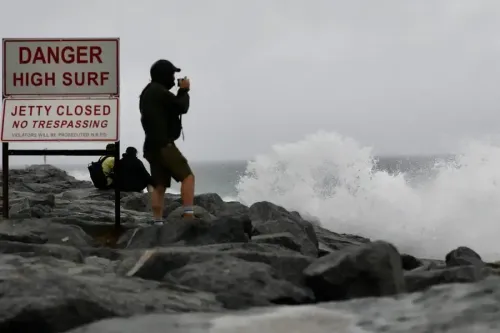
Large swells continued to pound Southern California's shoreline on Thursday, compounding damage from earlier storm cycles. The impact on coastal infrastructure has already been visible: in October, a 360-foot crack appeared in a coastal bluff beneath Pacific Coast Highway near Crystal Cove State Park, forcing Caltrans to restrict traffic to one lane in each direction while stabilisation crews worked on the slope.
A high surf advisory remained active for Malibu and Los Angeles County beaches through 9 am Friday, with waves between 6 and 9 feet forecast.
The 'Triple Threat': Waves, Rain, and Rising Sea Levels
Scientists warn the worst may still be ahead. The coming week is expected to bring unusually high 'king tides' running from Sunday through 27 November, which could coincide with large swells and further rainfall. Starting Monday, maximum coastal water levels in parts of Southern California could exceed 8 feet.
According to the California Coastal Commission, the season's peak tides are not even due until 24–26 November, 23–25 December, and 21–22 January.
Mark Merrifield, director of the Center for Climate Change Impacts and Adaptation at Scripps Institution of Oceanography, described the convergence as a 'triple threat.' 'We're facing a triple threat here in terms of coastal impacts in California associated with this El Niño event: higher waves, more rain, and higher sea levels,' he warned.
Historic El Niño on Record, Say Federal Agencies
The National Oceanic and Atmospheric Administration (NOAA) estimates roughly a 60 per cent probability — for the period from October through December at minimum — that this will be a 'historic' El Niño, one that would surpass every comparable event since records began in 1950. The US Geological Survey (USGS) has stated the event is 'projected to be the largest and most intense on record.'
Government Response and Infrastructure Spending
California Governor Gavin Newsom had already declared a statewide state of emergency on 21 September, and signed an executive order on 27 October establishing a Highway 1 Task Force to identify vulnerable sections of the coastal highway and accelerate protective works. Emergency project expenditures along the Big Sur section of Highway 1 totalled approximately $312 million between 2020 and 2026, according to the governor's office.
With peak tidal cycles still weeks away and storm systems continuing to develop, California's coastline faces a prolonged season of risk — and authorities are urging residents to remain on high alert.
Point of View
With each weather cycle landing on infrastructure already weakened by the last. The $312 million spent on Big Sur's Highway 1 alone underscores how chronic and expensive this exposure has become, yet that figure predates what NOAA now rates as potentially the strongest El Niño on record. The 'triple threat' framing from Scripps scientists is scientifically precise but also politically significant: it frames this as a climate-change acceleration story, not merely a weather anomaly. Governor Newsom's emergency declarations and task forces signal awareness, but the gap between preventive spending and the scale of projected damage suggests California's coastal adaptation strategy is running behind the curve.
NationPress
22 Nov 2026
Frequently Asked Questions
What is a Super El Niño and why is it hitting California so hard?
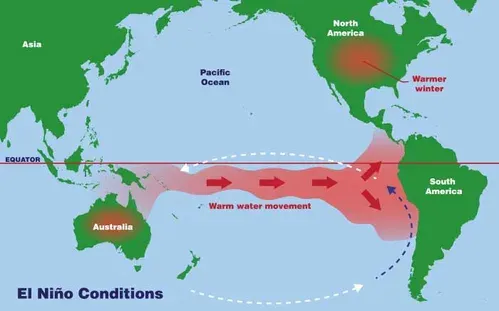
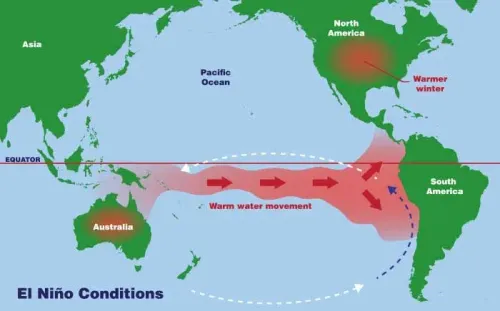
El Niño is a climate pattern caused by warmer-than-normal waters in the tropical Pacific, which brings wetter and stormier conditions to California. The current event is classified as 'super' because NOAA estimates a 60% probability it will surpass every El Niño on record since 1950, delivering extreme rainfall, elevated sea levels, and powerful swells to the state's coastline.
What are king tides and why are they dangerous this week?
King tides are the highest predicted tidal events of the year, occurring when the sun, moon, and Earth align. This week's king tides — forecast to run from Sunday through 27 November — are dangerous because they coincide with El Niño-elevated sea levels and storm swells, potentially pushing coastal water levels above 8 feet in parts of Southern California.
How much damage has the California coast already sustained?
A 360-foot crack appeared in a coastal bluff beneath Pacific Coast Highway near Crystal Cove State Park in October, forcing single-lane traffic restrictions. San Francisco broke a century-old rainfall record on Wednesday, flooding buildings and cutting power to over 51,000 customers. Emergency repairs along Big Sur's Highway 1 have cost approximately $312 million since 2020.
What has the California government done in response?
Governor Gavin Newsom declared a statewide state of emergency on 21 September and signed an executive order on 27 October establishing a Highway 1 Task Force to identify vulnerable coastal sections and fast-track protective works. Emergency expenditures along Big Sur's Highway 1 have totalled roughly $312 million from 2020 through 2026.
When will the worst coastal conditions be expected?
Scientists expect the most dangerous combination of king tides, swells, and rain to peak between Sunday and 27 November. The California Coastal Commission notes the season's highest tides are still ahead, with peak cycles forecast for 24–26 November, 23–25 December, and 21–22 January.