MP Weather Alert: 13 districts to face thunderstorms, gusty winds on Saturday

Synopsis
Madhya Pradesh is caught in a rare dual grip — thunderstorms battering 13 districts while Ratlam sizzles at 43.5°C. Driven by two troughs and a cyclonic circulation, this early-May disruption defies the state's usual heat pattern, with a sharp 3-4°C temperature spike forecast from Sunday once the storm system clears.
Key Takeaways
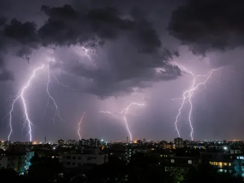
The Bhopal Meteorological Department has issued a thunderstorm and gusty winds alert for 13 districts in Madhya Pradesh on Saturday, 10 May 2025 .
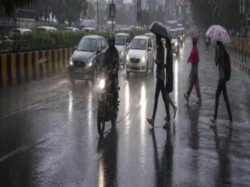
On Friday, strong winds and light rain were reported across more than 20 districts , including Bhopal .
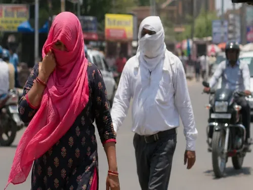
Ratlam recorded the state's highest temperature at 43.5°C ; Bhopal and Indore hit 41.2°C .
Western Disturbances, trough lines, and cyclonic systems are driving the unusual weather pattern since early May 2025 .
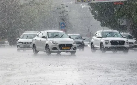
Temperatures are expected to rise by 3 to 4°C from Sunday once the storm system passes.
Farmers have been warned of potential crop damage from unseasonal rain and hailstorms.
Madhya Pradesh is experiencing turbulent weather driven by two active troughs and a cyclonic circulation, with the Bhopal Meteorological Department issuing a thunderstorm and rain alert for 13 districts on Saturday, 10 May 2025. On Friday, strong winds and light showers were already reported across more than 20 districts, including the state capital Bhopal.
Districts Under Alert
The 13 districts placed on alert for thunderstorms accompanied by strong winds are Narmadapuram, Betul, Chhindwara, Pandhurna, Seoni, Balaghat, Mandla, Dindori, Anuppur, Umaria, Shahdol, Sidhi, and Singrauli. Meteorologists have also warned of the possibility of lightning strikes in some of these areas.
On Friday, weather disturbances swept through a wider belt, affecting Bhopal, Seoni, Chhindwara, Raisen, Sagar, Damoh, Dewas, Khargone, Vidisha, Rajgarh, Tikamgarh, Ashoknagar, Shivpuri, Betul, Narsinghpur, Mandla, and Dindori, among others.
Heat Persists Alongside Storms
Despite the stormy conditions, intense heat continues to grip several cities across the state. Ratlam recorded the highest temperature at 43.5°C, followed by Shajapur at 42.6°C and Ujjain at 42.4°C. Bhopal and Indore both registered 41.2°C, Jabalpur recorded 38.8°C, and Gwalior stood at 37.5°C.
This unusual combination of storms and heat reflects a broader disruption to the state's typical early-May weather pattern, which is normally characterised by unrelenting dry heat.
Why the Weather Is Behaving Unusually
Meteorologists note that Madhya Pradesh has been witnessing atypical weather since the start of May 2025. Western Disturbances, trough lines, and active cyclonic systems are being cited as the primary drivers behind the anomaly. Storms, rainfall, and even hailstorms have repeatedly disrupted what is traditionally the peak of the pre-monsoon heat season.
This is not an isolated event — the confluence of multiple atmospheric systems simultaneously affecting a landlocked state like Madhya Pradesh is relatively uncommon for this time of year, according to meteorologists.
What Comes Next
The Meteorological Department has predicted that stormy and rainy conditions will persist through Saturday. From Sunday onwards, daytime temperatures across most cities are expected to rise sharply by 3 to 4 degrees Celsius, signalling a return to intense heat conditions.
Advisories for Residents and Farmers
Authorities have urged residents to exercise caution during adverse weather, advising them to avoid open spaces, trees, and utility poles during storms and lightning activity. Farmers across the state have been separately warned of potential crop damage due to unseasonal rain and hailstorms, adding to agrarian concerns ahead of the harvest season.
Point of View
Yet state-level crop insurance mechanisms remain slow to respond to rapid-onset weather events. The Meteorological Department's district-level alerts are a step forward, but the real gap lies in last-mile communication to rural communities and farmers who may not receive timely warnings.
NationPress
24 Jun 2026
Frequently Asked Questions
Which districts in Madhya Pradesh are on thunderstorm alert on Saturday?
The 13 districts under thunderstorm and gusty winds alert on Saturday are Narmadapuram, Betul, Chhindwara, Pandhurna, Seoni, Balaghat, Mandla, Dindori, Anuppur, Umaria, Shahdol, Sidhi, and Singrauli. Lightning strikes are also possible in some of these areas.
Why is Madhya Pradesh experiencing unusual weather in May 2025?
Meteorologists attribute the unusual weather to the simultaneous influence of two troughs and an active cyclonic circulation, compounded by Western Disturbances. This combination is relatively uncommon for early May, which is typically dominated by dry heat in the state.
What is the hottest city in Madhya Pradesh right now?
Ratlam recorded the highest temperature in the state at 43.5°C. Shajapur followed at 42.6°C and Ujjain at 42.4°C, while Bhopal and Indore both registered 41.2°C.
When will the storms subside and temperatures rise again?
The Meteorological Department has forecast that stormy and rainy conditions will persist through Saturday. From Sunday onwards, temperatures in most cities are expected to rise sharply by 3 to 4 degrees Celsius.
What precautions have authorities advised during the storms?
Authorities have urged residents to avoid open spaces, trees, and utility poles during storms and lightning. Farmers have been separately warned to safeguard crops against damage from unseasonal rain and hailstorms.