Nepal floods derail China's South Asia land bridge ambitions via BRI route
Synopsis
Last week's Bhotekoshi flood didn't just devastate Nepal's border communities — it exposed the structural fault line in China's BRI ambitions. With both the Rasuwa-Kerung and Tatopani routes now disrupted, Beijing's plan to route trade to Bihar, Uttar Pradesh, and Bangladesh through Nepal looks increasingly fragile, and its own dam-building in Tibet is drawing scrutiny as a compounding risk factor.
Key Takeaways
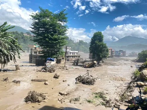
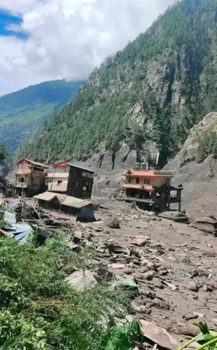
Catastrophic floods triggered by an ice and rock avalanche struck the Nepal-China border region last week, severely disrupting bilateral trade routes.
The Rasuwa-Kerung transit point — Nepal's primary trade gateway with China since 2015 — and the Tatopani border point are both affected.
China had planned to use the Nepal corridor to access markets in Bihar , Uttar Pradesh , and Bangladesh under the BRI .
Northern Nepal trade routes have been disrupted by monsoon landslides and floods almost every year for nearly a decade, according to reports.
China's planned Medog dam in Tibet, with a 60,000 MW projected capacity, has raised fears of seismic risk and downstream flooding for Nepal and other nations.
The 114-km Araniko Highway , completed in 1967 , remains the backbone of the Nepal-China land connection despite recurring damage.
Catastrophic floods and landslides that struck the Nepal-China border region last week have dealt a severe blow to Beijing's long-standing ambition of using Nepal as a land corridor to expand trade with India and Bangladesh, raising fresh questions about the viability of the Himalayan route under China's Belt and Road Initiative (BRI). The disaster has disrupted key transit points and exposed the structural fragility of cross-border infrastructure in the region.
Key Developments
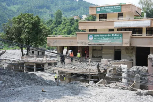
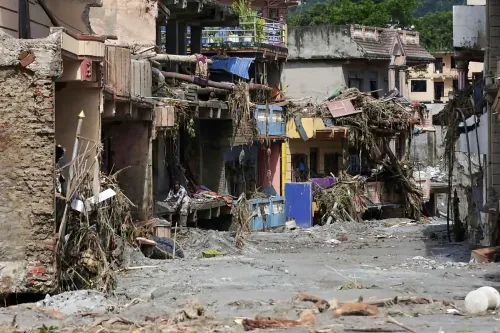
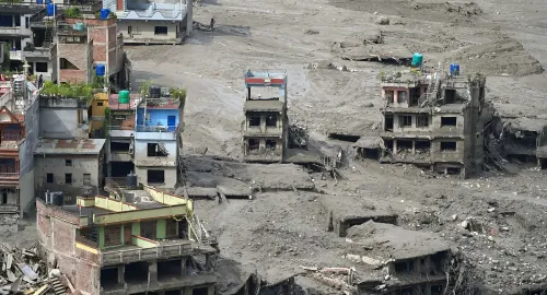
The Bhotekoshi River flood, attributed to an ice and rock avalanche, inundated large stretches of the Nepal-China border zone, devastating trade and tourism in the area. The Rasuwa-Kerung transit point — described as the 'lifeline of trade' between Nepal and China since the 2015 earthquake badly damaged the Araniko Highway — was among the routes severely affected. The Tatopani border point in Sindhupalchowk had already remained completely closed this season due to landslides along the Tatopani-Bahrabise section, according to reports.
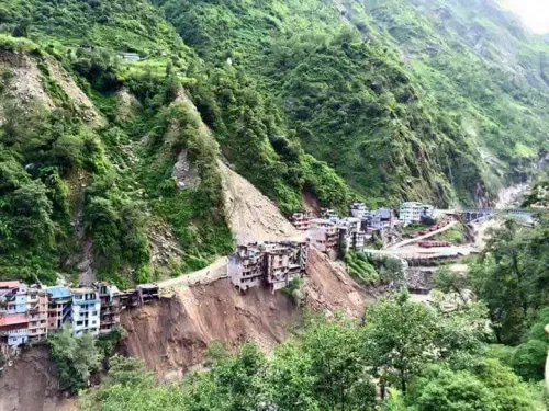
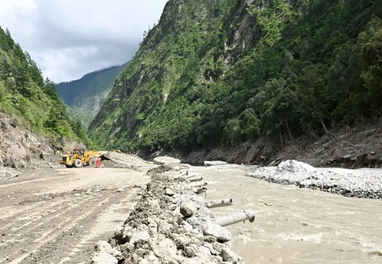
The 114-km Araniko Highway, which connects Nepal to China and was completed in 1967 under then King Mahendra reportedly with Chinese assistance, has been repeatedly battered. Northern trade routes are disrupted by landslides and floods almost every monsoon, blocking roads, washing away bridges, and bringing cargo movement to a near halt — a problem that has persisted for nearly a decade, according to a Kathmandu Post report published days before the latest deluge.
China's South Asia Trade Ambitions Under Strain
For China, the Nepal corridor represented a strategic opportunity to connect trade flows to Bihar and Uttar Pradesh in India, with onward access to Bangladesh. When a Nepal-China border upgrade was announced, officials in Beijing had stated that trade with third countries could be routed through this corridor in the future 'if there was agreement with a third country willing to sign separate agreements', according to the Nepali news site Kantipur.
Though China had committed to upgrading the border point and vulnerable sections of the highway under the BRI, reports suggest progress has been limited. Even after the 2024 floods and landslides, the two major land routes through Kerung and Tatopani were closed for over a month before bilateral trade resumed at the end of October. Analysts describe such closures as 'hardly an isolated event', noting that the road has been hit by landslides 'of varying severity almost every monsoon, cutting off the border for weeks or months.'
Infrastructure Fragility and Dam Concerns
The disaster has also intensified scrutiny of China's large-scale dam construction in Tibet. Experts have raised concerns that Beijing's mega dam projects pose significant risks to downstream nations in terms of human life, ecology, and regional security across the Hindu Kush Himalaya (HKH) region. China's planned Medog dam in Tibet, with a projected capacity of 60,000 MW, has drawn particular alarm over seismic risks and the potential for catastrophic downstream flooding.
The current crisis, critics argue, underscores a contradiction at the heart of Beijing's regional infrastructure strategy — investing in cross-border connectivity while simultaneously building upstream structures that heighten flood risk for the very corridors it seeks to develop.
What This Means for Regional Trade
Since the 2015 earthquake, Rasuwagadhi has served as Nepal's primary trade gateway with China, with trucks carrying clothes, electrical appliances, vehicles, machinery, and daily essentials passing through the narrow gorge of the Bhotekoshi River. That route is now severely disrupted. The Rasuwa-Kerung point came into operation in late 2014 and gained strategic importance after the earthquake the following year, according to the Kantipur report.
With both major northern trade arteries compromised, China's vision of Nepal as a functional land bridge to South Asia faces not just seasonal delays but growing structural scepticism. Whether Beijing accelerates BRI-linked upgrades in response — or whether the recurring monsoon damage renders the corridor economically unviable — will shape the region's trade architecture in the years ahead.
Point of View
Yet nearly a decade of annual closures suggests the infrastructure investment has not matched the strategic rhetoric. More troubling is the contradiction embedded in China's regional posture: it promotes downstream connectivity while building upstream mega-dams in Tibet that experts link to heightened flood risk for the very corridors it is developing. If Beijing cannot resolve this structural tension, Nepal's role as a South Asia land bridge will remain a blueprint, not a reality.
NationPress
16 Oct 2026
Frequently Asked Questions
How have the Nepal floods affected China's BRI trade plans?
The floods, triggered by an ice and rock avalanche in the Bhotekoshi River valley, have disrupted the Rasuwa-Kerung and Tatopani border crossings — the two main land trade routes between Nepal and China. This has set back Beijing's ambition to use Nepal as a corridor for trade with India and Bangladesh under the Belt and Road Initiative.
What is the Rasuwa-Kerung transit point and why does it matter?
Rasuwa-Kerung is Nepal's primary land trade gateway with China, operational since late 2014 and elevated in strategic importance after the 2015 earthquake damaged the Araniko Highway. It handles the bulk of Nepal-China cargo, including clothes, electrical appliances, vehicles, and machinery.
How often are Nepal's northern trade routes disrupted?
According to reports, Nepal's northern trade routes have been disrupted by landslides and floods of varying severity almost every monsoon for nearly a decade. In 2024, the Kerung and Tatopani routes were closed for over a month before trade resumed at the end of October.
What concerns have been raised about China's dam projects in Tibet?
Experts have warned that China's large-scale dam construction in Tibet poses risks to downstream nations in terms of flooding, ecology, and security across the Hindu Kush Himalaya region. China's planned Medog dam in Tibet, with a projected 60,000 MW capacity, has drawn particular alarm over seismic risk and the potential for catastrophic downstream flooding.
What was China's plan for Nepal as a trade corridor to South Asia?
Beijing had envisioned routing trade to Bihar and Uttar Pradesh in India, with onward access to Bangladesh, through upgraded Nepal border infrastructure under the BRI. Chinese officials had indicated that third-country trade could use the route if separate agreements were reached with willing nations.