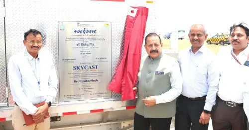
Delhi IGI Airport gets India's first SkyCast System for aviation weather

Synopsis
India joined an exclusive club of 19 nations with the inauguration of the SkyCast System at Delhi's IGI Airport — a multi-sensor atmospheric platform that can warn pilots of fog and turbulence up to three hours in advance. With a second unit already planned for Jewar Airport, this marks the start of a nationwide rollout under Mission Mausam.
Key Takeaways
India's first SkyCast System was inaugurated at Indira Gandhi International Airport, New Delhi on 29 May .
India is the 19th country globally to deploy the system; only 18 units existed worldwide before this installation.
The system integrates Radar Wind Profiler , SODAR , Microwave Radiometer , GFAS , and CL61 Lidar-based Ceilometer for real-time weather data.
Advance alerts can be issued to pilots within ~3-hour windows, reducing diversions, cancellations, and delays.
A second SkyCast unit is planned for Jewar Airport , with further rollouts at other airports to follow.
The initiative falls under Mission Mausam , the Centre's broader meteorological modernisation programme.
India's first SkyCast System was inaugurated at Indira Gandhi International Airport, New Delhi, on 29 May by Union Minister of State Dr. Jitendra Singh, marking a significant upgrade to the country's aviation weather monitoring infrastructure. The system is designed to reduce fog-related flight disruptions and deliver real-time atmospheric data to pilots and air traffic managers.
A Global Rarity Now in India
Only 18 such systems have been deployed worldwide prior to this installation, making India's IGI Airport home to the 19th SkyCast unit globally, according to Dr. Singh. A second unit is already planned for Jewar Airport, with further rollouts at additional airports to follow, the Ministry of Earth Sciences said in a statement.
What the SkyCast System Does
SkyCast integrates multiple atmospheric remote sensing technologies to monitor fog, turbulence, moisture, and visibility in real time. The system combines a Radar Wind Profiler, SODAR, Microwave Radiometer, Ground-based Fog Aerosol Spectrometer (GFAS), and a CL61 Lidar-based Ceilometer.
At its core, an advanced boundary-layer Radar Wind Profiler continuously measures wind speed, wind direction, turbulence, vertical velocity, and boundary-layer dynamics up to nearly 3 kilometres above the airport — parameters that are critical during aircraft descent and landing. The CL61 Lidar-based Ceilometer monitors the vertical structure of fog, enabling better prediction of visibility reduction and fog formation.
Impact on Flight Safety and Operations
The system is capable of issuing advance weather alerts to pilots and aircrew within short windows of around three hours, enabling informed decisions on the safest time for landing and helping avoid unnecessary diversions, cancellations, and delays. Flight disruptions caused by fog and turbulence are expected to drop significantly as a result.
Dr. Singh said SkyCast will bring a 'major transformation in aviation safety' by providing real-time information during critical weather situations, strengthening monitoring and warning capabilities across runways.
Broader Applications Beyond Aviation
Beyond its immediate aviation role, SkyCast observations are expected to support advanced forecasting models, artificial intelligence-enabled decision support systems, urban weather forecasting, pollution management, transport advisories, and disaster preparedness initiatives.
Dr. Singh attributed the initiative to Prime Minister Narendra Modi's vision under Mission Mausam, describing the deployment as an example of futuristic weather infrastructure being made possible through that programme. This comes amid a broader push by the Centre to modernise India's meteorological capabilities across sectors.
Point of View
With significant economic costs to airlines and passengers. The three-hour advance alert window is operationally meaningful, not just symbolic. The real measure, however, will be whether the system's data feeds are integrated into airline operational control centres in real time, or remain siloed within meteorological agencies. The planned Jewar rollout is also worth watching: as the NCR's second major hub comes online, having matched weather infrastructure at both airports will be essential to coordinated airspace management.
NationPress
25 Sept 2026
Frequently Asked Questions
What is the SkyCast System inaugurated at Delhi's IGI Airport?
SkyCast is an advanced multi-sensor atmospheric monitoring platform that combines Radar Wind Profiler, SODAR, Microwave Radiometer, Ground-based Fog Aerosol Spectrometer, and a CL61 Lidar-based Ceilometer to provide real-time data on fog, turbulence, moisture, and visibility. It is designed to help pilots and air traffic managers make safer decisions during critical weather conditions.
Why is India's SkyCast System significant globally?
India's installation at IGI Airport is only the 19th such deployment in the world, making it an exceptionally rare piece of aviation weather infrastructure. Prior to this, only 18 SkyCast systems had been deployed globally.
How does SkyCast reduce flight disruptions?
The system issues advance weather alerts to pilots and aircrew within approximately three-hour windows, enabling informed decisions on landing times and helping avoid unnecessary diversions, cancellations, and delays caused by fog and turbulence.
Where will the next SkyCast System be deployed in India?
According to the Ministry of Earth Sciences, a second SkyCast unit is planned for Jewar Airport, with further rollouts at additional airports across India to follow.
What is Mission Mausam and how does it relate to SkyCast?
Mission Mausam is Prime Minister Narendra Modi's initiative to modernise India's weather monitoring and forecasting infrastructure. The SkyCast deployment at IGI Airport has been described by Union MoS Dr. Jitendra Singh as a direct outcome of that programme's vision for futuristic meteorological capabilities.