Bihar CM Samrat Choudhary Surveys Flood Zones in West Champaran
Synopsis
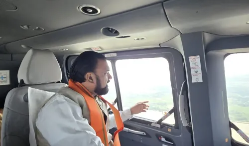
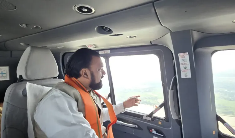
Bihar Chief Minister Samrat Choudhary conducted an aerial survey on 30 September 2026 of flood-affected villages in West Champaran district, covering Bagaha, Bairia, Yogapatti and Nautan blocks. The inspection signals the administration's intent to assess damage and coordinate relief for thousands of affected residents.
Key Takeaways
Samrat Choudhary , Bihar's Chief Minister, carried out an aerial survey of flood-hit areas in West Champaran district on 30 September 2026 .
The survey covered Bagaha , Bathna (Bairia block), Machharganwa (Yogapatti block), and Shivrajpur and Bankatwa (Nautan block), along with surrounding localities.
West Champaran borders Nepal and is annually battered by rivers including the Gandak , making it one of Bihar's most flood-vulnerable districts.
Aerial surveys by the Chief Minister are an established first-response mechanism in Bihar, typically preceding formal damage assessments and relief distribution.
Follow-up actions expected include crop-loss assessments, relief material distribution, and potential requests for central government assistance.
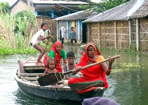
Floodwaters have swallowed villages across West Champaran, and on Wednesday, 30 September 2026, Bihar Chief Minister Samrat Choudhary took to the skies to see the damage for himself — conducting an aerial survey of inundated settlements across multiple blocks of the district.
Villages Under Water: What the Survey Covered
The Chief Minister's Office confirmed that Samrat Choudhary surveyed flood-hit areas in Bagaha, the Bairia block village of Bathna, Machharganwa in Yogapatti block, and Shivrajpur and Bankatwa in Nautan block — along with surrounding affected localities. The sweep covered a wide arc of the district's most vulnerable terrain, where low-lying agricultural land and dense rural settlements sit directly in the path of seasonal overflow.
West Champaran's Annual Battle With the Monsoon
West Champaran, a northern Bihar district sharing a border with Nepal, is among the state's most flood-prone zones. Rivers originating in the Himalayan foothills — including the Gandak and its tributaries — surge during the monsoon, overwhelming embankments and draining slowly through low-gradient plains. Drainage bottlenecks compound the problem, leaving communities in blocks like Bairia, Yogapatti, and Nautan stranded for days or weeks at a stretch.
Bihar's successive administrations have used aerial inspections as a first-response tool precisely because ground access collapses when roads flood. A Chief Minister's overfly signals the administration's intent to prioritise the affected zone — and typically precedes formal damage assessments, relief distribution orders, and, in severe cases, requests for central government assistance.
What Comes Next for Bagaha and Beyond
The immediate focus will shift to ground-level follow-through: crop-loss assessments for farmers whose fields are submerged, distribution of food and relief materials to cut-off villages, and a block-wise damage report that can form the basis of any compensation claims. Residents of Shivrajpur, Bankatwa, and Machharganwa — among the localities specifically named in the survey — will be watching for concrete relief announcements in the coming days.
An aerial survey is a statement of intent. The harder test is what lands on the ground.
Point of View
A district that has suffered recurring flood neglect, the optics matter as much as the logistics. Bihar's flood governance has long been criticised for the gap between high-level inspections and last-mile relief delivery; the real test of this administration's intent will be the speed and scale of compensation and infrastructure repair that follows. With monsoon flooding increasingly severe across the Nepal-border districts, the state's ability to move from aerial assessment to ground action will define whether this visit is remembered as leadership or theatre.
NationPress
30 Sept 2026
Frequently Asked Questions
Which areas did Bihar CM Samrat Choudhary survey during the West Champaran flood inspection?
The Chief Minister surveyed flood-affected areas in Bagaha, Bathna village in Bairia block, Machharganwa in Yogapatti block, and Shivrajpur and Bankatwa in Nautan block, along with surrounding localities in West Champaran district.
Why does West Champaran flood so frequently?
West Champaran borders Nepal and lies in the path of rivers like the Gandak that originate in the Himalayan foothills. Heavy monsoon rainfall upstream causes these rivers to overflow, while poor drainage infrastructure in the low-lying plains worsens and prolongs inundation.
What is the purpose of an aerial flood survey by the Chief Minister?
An aerial survey allows the Chief Minister to assess the extent of inundation across a wide area quickly when roads are flooded and ground access is cut off. It typically precedes formal damage assessments, relief distribution orders, and requests for central government assistance.
What relief measures are expected after the West Champaran aerial survey?
Following such inspections, the standard follow-up includes block-wise crop-loss assessments for farmers, distribution of food and essential supplies to stranded villages, and formal damage reports that can support compensation claims or central disaster relief fund requests.
When did Bihar CM Samrat Choudhary conduct the West Champaran flood survey?
The aerial survey was conducted on Wednesday, 30 September 2026, as confirmed by the Chief Minister's Office of Bihar.