Odisha CMO: AI and Drones to Secure 480 km Coastline
Synopsis
Odisha's Chief Minister's Office declared on 25 June 2026 that the state is integrating AI, unmanned systems, and advanced surveillance into its coastal security framework along the 480 km Bay of Bengal coastline, aligning with India's broader maritime growth and security goals.
Key Takeaways
The Chief Minister's Office of Odisha announced on 25 June 2026 the adoption of AI, unmanned systems, and advanced surveillance for coastal security.
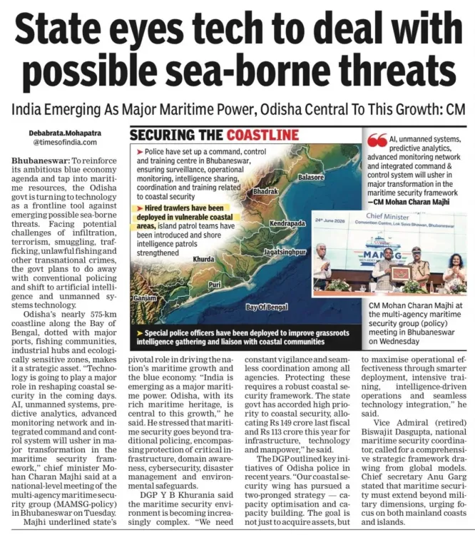
Odisha has a 480-kilometre coastline along the Bay of Bengal , among the longest of any Indian state.
India's Coastal Security Scheme , launched in 2005 and expanded after the 2008 Mumbai attacks , provides the policy foundation for state-level maritime security upgrades.
The move aligns with the SAGAR vision (2015) and Atmanirbhar Bharat (2020) push for indigenous, technology-driven coastal defence.
Key stakeholders include coastal fishermen , port operators , and Indian Coast Guard units operating on the eastern seaboard.
Rollout timelines and inter-agency coordination with the Indian Coast Guard's national grid remain the critical next steps to watch.
The Chief Minister's Office of Odisha announced on Thursday, 25 June 2026 that the state is deploying artificial intelligence, unmanned systems, and advanced surveillance technologies to build a smarter coastal security framework along its 480-kilometre Bay of Bengal coastline. The move positions Odisha as a frontrunner in technology-driven maritime protection on India's eastern seaboard.
Context
The CMO's post stated that Odisha is 'embracing AI, unmanned systems and advanced surveillance to build a smarter, stronger coastal security framework, protecting its coastline while powering India's maritime growth.' The declaration signals a formal policy orientation toward next-generation tools rather than conventional patrol assets alone. Odisha's coastline, bordering the Bay of Bengal, is among the longest of any Indian state and encompasses major ports, fishing harbours, and sensitive marine zones.
Coastal security in India has been a shared responsibility between state governments, the Indian Coast Guard, and the Navy since the Coastal Security Scheme was first rolled out in 2005. The scheme was significantly expanded after the 2008 Mumbai attacks exposed critical gaps in maritime surveillance, triggering a nationwide overhaul that equipped states with interceptor boats, radar stations, and joint operations control rooms.
Policy Backdrop
India's broader maritime security architecture has evolved through several policy layers. The SAGAR vision articulated in 2015 — Security and Growth for All in the Region — and the country's Maritime Doctrine both emphasised technology-driven coastal protection alongside blue economy development. The Sagarmala Project, also launched in 2015, brought port-led economic development to states including Odisha, tying infrastructure investment to trade corridor ambitions.
The 2020 Atmanirbhar Bharat push accelerated state-level adoption of UAVs, AI-based video analytics, and unmanned surface vessels for surveillance and patrol. Eastern seaboard states have since been aligning these upgrades with national port modernisation programmes. Odisha's announcement fits squarely within this progressive layering of technology onto the coastal security grid that has been underway since the late 2000s.
Stakeholders and Impact
Coastal fishermen stand to benefit from improved search-and-rescue responsiveness enabled by AI-linked surveillance and drone coverage. Port operators at facilities such as Paradip Port — one of India's major cargo hubs — could see enhanced perimeter security and faster threat-response protocols. State police marine units and Indian Coast Guard personnel operating along the Odisha coast are the primary operational beneficiaries of the new systems.
At the same time, the integration of unmanned systems raises questions about coordination protocols between state agencies and central forces, a challenge other maritime states have navigated through joint operations centres. The broader implication for India's maritime growth narrative is significant: a technologically fortified eastern coastline supports both trade security and the country's ambitions as a regional maritime power in the Indian Ocean.
What's Next
Attention will now turn to the rollout timelines for specific AI-linked surveillance projects in Odisha and whether other coastal states will announce similar upgrades at upcoming national maritime security reviews. The model being developed here — combining unmanned aerial systems, AI analytics, and networked radar — could serve as a template for replication across India's roughly 7,500-kilometre coastline. How Odisha coordinates these state-level capabilities with the Indian Coast Guard's national grid will be a key measure of the initiative's operational effectiveness.
Point of View
Not merely passive recipients of central scheme funds. The timing, amid growing emphasis on the blue economy and Indian Ocean geopolitics, suggests state governments are positioning themselves as credible security actors alongside the Coast Guard and Navy. If Odisha's model proves operationally sound, it could set a benchmark that pressures other coastal states to accelerate similar upgrades at the next national maritime security review. The real test, however, will be seamless integration with the central coastal surveillance network rather than parallel, siloed state systems.
NationPress
25 Jun 2026
Frequently Asked Questions
What is Odisha doing to improve coastal security?
Odisha is deploying artificial intelligence, unmanned aerial systems, and advanced surveillance technologies along its 480 km Bay of Bengal coastline to build a more effective maritime security framework, as announced by the Chief Minister's Office on 25 June 2026.
How long is Odisha's coastline?
Odisha has a coastline of approximately 480 kilometres along the Bay of Bengal, making it one of the longer state coastlines in India.
What is India's Coastal Security Scheme?
The Coastal Security Scheme was launched in 2005 and significantly expanded after the 2008 Mumbai attacks . It provides state governments with interceptor boats, radar stations, and joint operations control rooms to strengthen maritime surveillance in coordination with the Indian Coast Guard.
What is the SAGAR vision and how does it relate to Odisha's announcement?
SAGAR — Security and Growth for All in the Region — is India's maritime doctrine articulated in 2015 that emphasises technology-driven coastal protection alongside blue economy development. Odisha's AI and drone integration directly aligns with this national framework.
Which agencies are involved in coastal security in Odisha?
Coastal security in Odisha involves the Indian Coast Guard , state police marine units, and the Indian Navy, all coordinating through joint operations structures established under the national Coastal Security Scheme.