South Bengal heavy rain alert: Bay low-pressure to intensify into depression

Synopsis
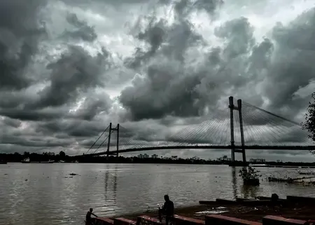
A strengthening low-pressure system over the northwest Bay of Bengal is set to turn into a depression and drench south Bengal through Monday — with orange alerts already active in South 24 Parganas and East Midnapore. Fishermen have been barred from the sea, and the system's path over the next 48 hours will determine whether coastal districts face worse than currently forecast.
Key Takeaways
The RMC Alipore has forecast heavy to very heavy rain across south Bengal districts through Monday, 7 July .
A low-pressure area in the northwest Bay of Bengal is expected to intensify into a depression and move west-northwest.
An orange alert is in force for South 24 Parganas and East Midnapore ; multiple districts are under yellow alert .
Gusty winds of 40–50 kmph and thunderstorms are expected across south Bengal districts.
Fishermen have been advised not to venture into the sea until Monday due to rough conditions in the north Bay of Bengal.
North Bengal faces no major rainfall activity through Monday, though a yellow alert for light rain and lightning remains active.
The Regional Meteorological Centre (RMC) at Alipore has issued a heavy to very heavy rainfall forecast for south Bengal districts, including Kolkata, through Monday, 7 July, as a low-pressure area over the northwest Bay of Bengal is expected to intensify into a depression and move west-northwest. Fishermen have been advised to stay off the sea until Monday as conditions in the north Bay of Bengal are expected to remain rough.
What the Weather System Looks Like
According to RMC officials, the low-pressure system currently sitting over the northwest Bay of Bengal will gain strength and develop into a depression before tracking westward and northwestward. 'A low pressure is present in the northwest Bay of Bengal. It will increase in strength and turn into a depression. Then this new system will move west and northwest. This will cause heavy to very heavy rain in south Bengal districts till Monday,' an official said.
Light to moderate rain accompanied by thunderstorms and gusty winds of 40–50 kmph is expected across all south Bengal districts in the near term.
District-Level Alerts in Force
An orange alert for very heavy rain is currently active in South 24 Parganas and East Midnapore, where scattered heavy rainfall is likely on Saturday. A yellow alert for heavy rain covers Jhargram, West Midnapore, and Howrah for Sunday, while Kolkata, Hooghly, North 24 Parganas, East Burdwan, and West Burdwan also fall under yellow alert on the same day.
Yellow alerts for heavy rainfall will continue into Monday across East Midnapore, West Midnapore, Jhargram, Bankura, Purulia, South 24 Parganas, West Burdwan, and Birbhum. Thunderstorms with lightning are likely in parts of South 24 Parganas and East Midnapore on Tuesday and Wednesday as residual effects of the system linger.
North Bengal Spared for Now
In contrast, North Bengal is not expected to see any major rainfall activity through Monday. All districts in the region remain under a yellow alert for light to moderate rain and lightning, but no heavy rain warning has been issued. This divergence between the two sub-regions is characteristic of Bay-of-Bengal-driven systems, which typically deliver their heaviest impact along the southern and coastal districts before weakening inland.
Kolkata Temperature and Conditions
On Friday, 4 July, Kolkata recorded a maximum temperature of 33.2 degrees Celsius, marginally above the seasonal normal by 0.6 degrees. The minimum temperature settled at 26.7 degrees Celsius, in line with the seasonal average. Humidity levels are expected to rise sharply as the depression draws closer over the weekend.
What to Watch Next
The trajectory and intensity of the depression will be the key variable over the next 48–72 hours. If the system intensifies further or slows its westward movement, rainfall intensity across coastal south Bengal districts could exceed current forecasts. Authorities are monitoring the situation, and residents in low-lying areas of South 24 Parganas and East Midnapore have been urged to remain alert.
Point of View
Yet district-level preparedness — particularly in flood-prone South 24 Parganas — remains uneven year after year. The orange alert is a formal warning tool, but its effectiveness depends entirely on last-mile communication to fishing communities and residents in low-lying areas, where past cyclonic events have shown significant gaps. The fact that North Bengal remains largely unaffected underlines how sharply rainfall distribution diverges across the state during such systems, a detail that often gets lost in state-wide weather headlines. Authorities would do well to pre-position relief assets in coastal districts rather than wait for the depression's final track to be confirmed.
NationPress
4 Jul 2026
Frequently Asked Questions
Why is south Bengal expecting heavy rain this week?
A low-pressure area over the northwest Bay of Bengal is expected to intensify into a depression and move west-northwest, directly affecting south Bengal districts. The RMC Alipore has forecast heavy to very heavy rainfall across the region through Monday, 7 July.
Which districts are under orange alert in West Bengal?
South 24 Parganas and East Midnapore are currently under an orange alert for very heavy rain. Several other south Bengal districts, including Kolkata, Howrah, Hooghly, and both Burdwan districts, are under yellow alerts for heavy rain.
Are fishermen allowed to go to sea during this weather system?
No. The RMC has advised fishermen not to venture into the sea until Monday, as conditions in the north Bay of Bengal are expected to remain rough due to the intensifying low-pressure system.
Will North Bengal also be affected by heavy rain?
North Bengal is not expected to see major rainfall activity through Monday. All districts in the region remain under a yellow alert for light to moderate rain and lightning, but no heavy rain warning has been issued.
What is Kolkata's current weather like?
On Friday, 4 July, Kolkata recorded a maximum temperature of 33.2 degrees Celsius, marginally above normal, with a minimum of 26.7 degrees Celsius. Humidity is expected to rise sharply as the depression approaches over the weekend.