DRDO tests indigenous High-Altitude Airship at 21 km in stratospheric milestone

Synopsis
India's DRDO has quietly crossed a major aerospace threshold — a domestically built lighter-than-air platform reaching 21 km and hovering in the stratosphere for over 30 minutes. For a country with pressing border surveillance needs and an ambition to cut defence imports, a home-grown HAPS capability changes the strategic calculus on persistent wide-area monitoring.
Key Takeaways
DRDO successfully flight-tested its indigenous High-Altitude Platform System (HAPS) on 6 October 2026 .
The airship reached 21 km above mean sea level and sustained flight at 20 km AMSL for over 30 minutes .
Real-time video and telemetry were transmitted continuously to a ground control station throughout the trial.
The platform was developed by Aerial Delivery Research and Development Establishment (ADRDE), Agra , a DRDO laboratory.
The trial involved Indian Air Force, CEMILAC, DGCA , and Airports Authority of India .
Defence Minister Rajnath Singh hailed the trial as a milestone in India's aerospace self-reliance under Aatmanirbhar Bharat .
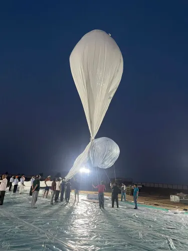
The Defence Research and Development Organisation (DRDO) on Tuesday, 6 October 2026, successfully completed a flight trial of its indigenously developed High-Altitude Platform System (HAPS), with the airship reaching an altitude of 21 km above mean sea level and sustaining stratospheric flight for over 30 minutes. The achievement marks a significant leap in India's indigenous surveillance and aerospace capabilities under the Aatmanirbhar Bharat initiative.
What the Flight Trial Demonstrated
According to the Ministry of Defence, the experimental platform climbed to 21 km above mean sea level (AMSL) and held an altitude of approximately 20 km AMSL for more than 30 minutes before receiving a command to descend. The system was subsequently recovered safely, and all flight performance data was analysed to evaluate mission parameters.
'The experimental flight attained an altitude of 21 km above mean sea level (AMSL) and remained at an altitude of 20 km AMSL for more than 30 minutes, before it was commanded to descend back to ground. The system was successfully recovered and flight performance data was analyzed,' the ministry stated.
Throughout the flight, real-time video feeds and vehicle performance telemetry were transmitted continuously from the airborne platform to a ground control station, confirming the system's command-and-control architecture.
Onboard Systems and Payloads
Officials said the platform carried a suite of instrumentation and control packages, including an inertial measurement unit, a GPS receiver, onboard cameras, and altitude control mechanisms, along with several other subsystems, all of which reportedly functioned as intended throughout the mission. The lighter-than-air system is being designed for long-endurance operations in the stratosphere, enabling persistent surveillance, communications relay, and environmental monitoring applications.
Agencies Behind the Trial
The flight trial was conducted in coordination with multiple agencies, including the Indian Air Force, the Centre for Military Airworthiness and Certification (CEMILAC), the Directorate General of Civil Aviation (DGCA), the Airports Authority of India (AAI), and other civil authorities. The platform is being designed and developed by the Aerial Delivery Research and Development Establishment (ADRDE), based in Agra, a DRDO laboratory.
Government Response and Strategic Significance
Defence Minister Rajnath Singh congratulated DRDO, the Indian Air Force, public sector undertakings, and industry partners on the successful trial. He described the achievement as an important milestone in India's path towards self-reliance in advanced aerospace technologies. The stratosphere — spanning roughly 12 km to 50 km above Earth — offers unique advantages for persistent wide-area surveillance and communications, sitting above commercial air traffic and below conventional satellites. Notably, this positions India among a small group of nations with demonstrated stratospheric airship capability, alongside the United States, China, and select European programmes. This comes amid heightened focus on India's border monitoring requirements, making long-endurance high-altitude platforms of direct strategic value.
What Comes Next
The HAPS programme is expected to progress towards extended-duration trials and potential integration of mission-specific payloads. Defence analysts expect the platform to eventually support both military surveillance and civilian applications such as disaster monitoring and telecom relay in remote regions.
Point of View
Harder to intercept than drones, and capable of persistent wide-area coverage that no conventional UAV can match. India's border surveillance gaps, particularly along the northern front, have been a recurring operational concern, and a long-endurance high-altitude platform directly addresses that. The critical question now is timeline: from a 30-minute demonstrator to an operationally viable platform capable of days-long missions is a substantial engineering leap, and DRDO's track record on programme timelines warrants scrutiny. The involvement of CEMILAC and DGCA from the outset, however, signals a more structured certification pathway than past indigenous programmes have followed — which is an encouraging process signal.
NationPress
6 Oct 2026
Frequently Asked Questions
What is the DRDO High-Altitude Platform System (HAPS)?
The DRDO HAPS is an indigenously developed lighter-than-air stratospheric airship designed for long-endurance surveillance, communications relay, and monitoring missions. It is being developed by the Aerial Delivery Research and Development Establishment (ADRDE) in Agra, a DRDO laboratory.
How high did the DRDO airship fly during the test?
The platform reached an altitude of 21 km above mean sea level and sustained flight at approximately 20 km AMSL for more than 30 minutes before being commanded to descend. The system was successfully recovered after the trial.
Why does stratospheric flight matter for India's defence?
The stratosphere, between roughly 12 km and 50 km above Earth, sits above commercial air traffic and below satellites, making it ideal for persistent wide-area surveillance and communications relay. For India, this is particularly relevant for monitoring remote border regions where conventional drones and satellites have coverage or cost limitations.
Which agencies were involved in the DRDO HAPS flight trial?
The trial was conducted in coordination with the Indian Air Force, Centre for Military Airworthiness and Certification (CEMILAC), Directorate General of Civil Aviation (DGCA), Airports Authority of India (AAI), and other civil authorities, reflecting a multi-agency certification approach.
What did Defence Minister Rajnath Singh say about the DRDO HAPS test?
Defence Minister Rajnath Singh congratulated DRDO, the Indian Air Force, public sector undertakings, and industry partners, describing the achievement as an important milestone in India's journey towards self-reliance in advanced aerospace technologies under the Aatmanirbhar Bharat initiative.